Across Arizona 2022
OCTOBER 11 – NOVEMBER 10, 2022
COMPLETED
THE ROAD TO THE IMPOSSIBLE IS REACHED THROUGH POSSIBLE STEPS!!!
Welcome to the 30 Day Stateline Challenge. This challenge was created as a personal endeavor to dedicate 30 days towards becoming stronger physically, mentally, spiritually, and towards making a HUGE impact in the lives of others.
For 30 days, you will have the opportunity to challenge yourself to run, walk, or crawl as far and as long as possible.
THE CHALLENGE: Cover as many indoor or outdoor miles within a 30 day period using foot power. Simple…but not easy 🙂
Why do it? Because its very achievable for most people committed to living a better life and very challenging for those who want to push themselves to greater levels of personal discipline and higher satisfaction. There is no timeclock, no required location to show up, or no one to tell you what you can or can’t do. It’s you against you…the best way to compete against yourself.
WHY DONATE YOUR MILES
We call it leveraging internal and external accountability. By making a commitment to something greater than yourself you’re able to create a greater “WHY” which leads to a better you and a bigger impact. At HAU Gear our initiative is that of equipping women of all ages, living as villagers in remote parts of Nepal, with the vocational skills necessary to bring economic hope to themselves, their families, and their community. We run to change our life and in the process change the lives of others. To learn more about our initiative in Nepal CLICK HERE
Our goal from this 30 day challenge is to raise $30,000 to support sewing clinics throughout the Ruby Valley region of Nepal for 2023. The aim is to empower young ladies in each village throughout the region with the skills, tools, and confidence to sew items for the local schools within those communities. 100% of your donation and support goes towards that initiative in Nepal. Click Here to see some of our past student graduates.
THE CHALLENGE GUIDELINES
There are no limit to how many miles you can run or walk in a day. Even running 30 miles total during the 30 day challenge would be a super awesome achievement. You choose the location to run and the time of day. Yes, you can run streets or trails…or even indoors. No, you can’t have someone else run for you. That’s a naughty thing to do. We also call it cheating…on yourself. There is no limit to how many people can sponsor you. 100% of all the proceeds go to our HAUGEAR nonprofit foundation to help create sustainable vocational education for the villagers in Nepal (Check out our clinics) You do not need to be sponsored to run. This is a totally FREE event…but it would be awesome if others wanted to support you and sponsor the initiative 🙂 Can you run and raise awareness and support for another cause? Absolutely! Simply let us know which nonprofit you would like to promote and we’ll reach out to them to let them know you want to raise support for them. That way you can have people and corporations make a pledge for each run you complete and have that pledge benefit your nonprofit.
We are so thankful for our partnership with Alpine Ramble Trekking. Without their support and leadership our work in Nepal would not be possible. If you are looking for a trek of a lifetime please visit their site and book one of their amazing treks throughout the most amazing destinations in the world. Take their Ruby Valley Discovery Trek and see where our mission began.
We are so proud of the work the Alpine Ramble Team is doing to provide continued sewing education to the students in Ruby Valley. Currently they are learning how to make shoulder bags to be distributed this Christmas to children in the villages. We are hoping that in the near future we can open a retail store in Thamel (the trekking capital of the world) to showcase the products being made in the villages and thereby help the students create sustainable income for themselves and their families.
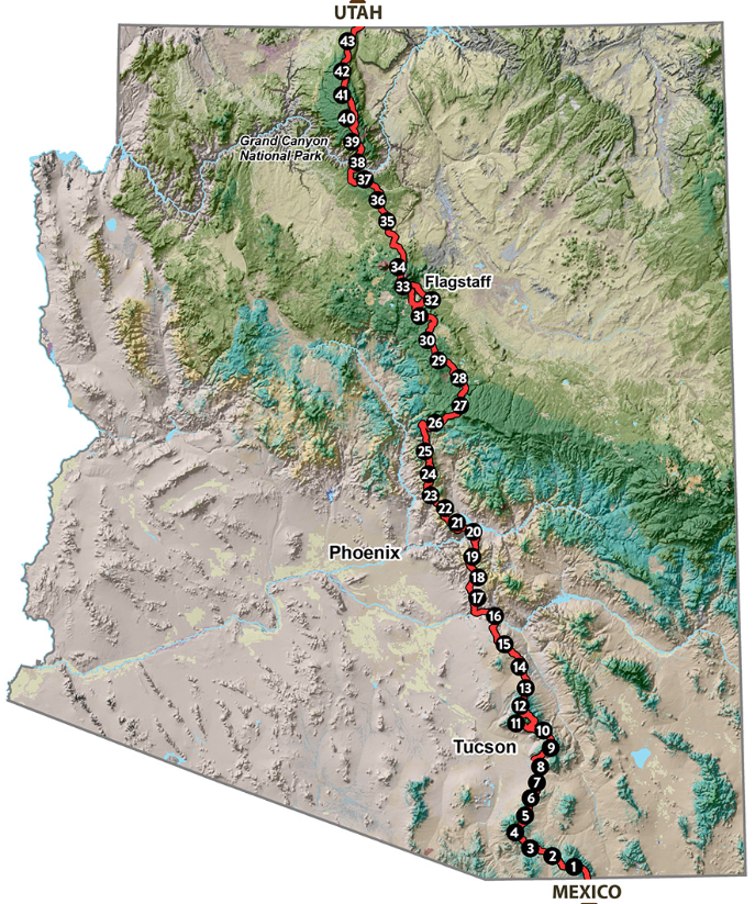
Life can be challenging. Often we might find ourselves being challenged by things we feel we cannot control. We get that! The Stateline Challenge has been designed to empower us with the faith and hope necessary to develop better ways of learning how we might respond to the daily challenges we face in life. Simply put, its a goal of crossing every state within the United States on foot. Whether you choose to go east to west, west to east, north to south, or south to north, we know that any direction is a direction towards forward movement. This year, during our 30 Day Challenge to bring awareness to our ministry in Nepal, we are working on seeing how far we can run, walk, or crawl across the state of Arizona from north to south. Here is our Journey!
On October 11th we began our journey on foot across Arizona, starting at the Utah/Arizona Terminus, via the Arizona Scenic National Trail. Using trail systems, forest roads, and highways, we have been moving towards getting to the Mexican border travelling through Arizona. And in the process we are hoping to bring more awareness to the work we are doing in Nepal…helping to create sustainable hope through sewing and development in remote regions of the Ruby Valley District in Nepal. To learn more, click here.
Updates of our current progress and route selections
RESULTS
542.9 total miles — 23.6 miles per day average — 23 Days on foot — 7 Days in recovery
Stage 1
Day 1: Evening start – AZT; 5.7 miles
Day 2: AZT; 25 miles
Day 3: Hwy 67; 26 miles
Day 4: 5 miles on Hwy 67; 16.6 miles on AZT; 21.6 miles
Day 5: M99.4 to Cottonwood CG to South Kaibab to Mather CG; 16.2 miles
Day 6: M99.4 to Tusayan to M115.9; 16 miles
Day 7: M115.9 – M148.2; 30 miles
Day 8: M148.2 to M162.8 to Hwy 180 S to flag; 30.6 miles
Day 9: 180 S to Flagstaff: 19 miles
Recovery
Summary: 190 subtotal miles; 21.12 miles per day average
Stage 2
Day 10: Flag UT M4.1 to Canyon Vista CG; 6 miles
Day 11: CVCG via Lake Mary Rd to Mormon Lake; 26 miles
Day 12: Mormon Lake via LMR to Jack’s Place to Mustang Gas Station; 27 miles
Day 13: JP via 87 (S) to Pine/Control rd; 25 miles
Day 14: Pine (87) to Payson (260) to Rye country store to 260/188 rest area; 29 miles
Day 15: 87 S to 188 S to Roosevelt Lake Beach; 25 miles
Day 16: 188 S to Roosevelt Lake Marina to Spring Creek store; 18 miles
Recovery
Summary: 156 subtotal miles; 22.28 miles per day average
Stage 3
Day 17: 188 to 60 to Globe; 25 miles
Day 18: 70 to 77 to Winkleman; 36 miles
Day 19: 77 passed Mammoth towards Oracle; 26 miles
Day 20: 77 to Catalina Inn; 21 miles
Day 21: 77 to Quality Inn Tucson Airport; 28 miles
Day 22: Nogales Hwy to Canoa Rest Area; 29 miles
Day 23: Freeway 19 to Nogales US/Mexico Border: 33.8 miles
AZ Stateline Challenge Complete
Summary: 196.8 subtotal miles; 28.11 miles per day average
Note: google map coordinates are approximates as mapping would allow. Mileage indicated for each stage is accurate as travelled.
***VIEW GEAR LIST CLICK HERE*** / Download the AZT App on your phone to get info on the trail, water sources, gateway communties, trailheads, and more. To reach us directly send an email at [email protected]
Happy Birthday sweetheart. You have been a constant inspiration to me for more than half of my life. You are an amazing mother, partner, wife, companion, and bossom friend. I love you and cherish you. Have an amazing year. May you continually feel God's love and our love for you. …
@haugear – this season I am especially thankful to Dil, Urmila, and Alpine Ramble Trekking (ART) for their ministry to the children in the villages of Khading and Lapa.
They have sewed and distributed 600 shoulder bags, with notebooks, crayons, and treats to an entire school district. ♥️♥️♥️
#rubyvalley #nepal #alpinerambletreks #christmas #outreach …
@haugear
So I'm watching a documentary called Racing Arizona about someone trying to beat the fastest known time (fkt) on the Arizona Trail. https://youtu.be/VOPRcISQ6Fw
I paused to share this when I realized he's so far in the documentary completed 529 miles of the AZT in 9 days which took me 542 miles to do on roads in 23 days. But when I saw his feet I felt compelled to share this. He finished the entire trail in 13 days, 3 hrs+. A highly recommended watch for those seeking inspiration.
I'm not gonna tag anyone on this to spare those with a weak stomach. I've got so far to go and so much to learn in order to complete the Stateline Challenge. 🤦🥵🏃♂️ …
@haugear
Why someone would ever choose a comfy bed over sleeping on the ground in a rest area I'll never know. 🙂
.
Ok so for the geeks like me, that want to know, here are the final stats:
TOTAL MILES: 542.9
Average miles per day: 23.6
Total days in travel: 23
Total days in recovery: 7
If you'd like to see the complete breakdown of each stage along with an interactive Google map you can check it out at www.haugear.com/30day2022
The background song was on repeat throughout the entire challenge. I love the line, "You say you don't know
You won't know until you begin" ♥️ …
@haugear
33.8 miles today and its a wrap. The 30 day AZ Stateline challenge is now complete. Thank you for everyone that has prayed for me, sent good juju beans, supported, sponsored, donated, and made me smile.
.
I have learned much about trusting in a power greater than myself, accepting the things I cannot change, courage to change the things I can, and the wisdom to know the difference. 🙏
.
If you are able and willing we'd love your support to fund our sewing ministry in Nepal for 2023. You can learn more at www.haugear.com/30day2022 …
@haugear
29 miles down. Followed the railroad tracks for the first 22 miles. 38 miles to go. Consistent headwind all day. It made me work for every step. Healthy and in fairly good spirits 🤪 …
@haugear
28 miles down for today. 67 miles to go. Amazing the things you find on the side of the road. If I had a toolbox with me I could have picked an entire mechanics tool set 🙂 – think I'll keep the black diamond locking carabiner. …
@haugear
I know I'll be sleeping indoors tonight but its not like it's a 5-star resort. They don't even have a heated jacuzzi in the room. Now that's real suffering. I looked…no bed bugs (I think).
21 miles for today but my feet are grateful. …
@haugear
Good morning. Beautiful morning. Heading west, southwest today. This picture is the sunrise to my back. Gonna make a recovery stop in Catalina and gear up for the last final days of push due S towards the border. All is well with my soul. 🙂 …
@haugear
27 miles today. Sleeping cowboy style tonight. John Wayne would be proud of me. 🏇 7 miles in the morning to breakfast. I'm hungry already 🍛 …
@haugear
First 20 mile leg of the day done. Time for linner and then a few more miles until time to find a place to tarp somewhere between here and Oracle. …
@haugeear
Well where do I start. An incredible unexpected day.
….
Started off early excited about going downhill from 3,500 to 2,000. NOPE (see pic). There is no down without first going up in AZ.
….
Planned on 29 miles. NOPE. Both campgrounds were closed along the way.
….
Made it 36 miles to Winkleman excited about the campground there. NOPE. Biker event with an AC/DC tribute band. So up the hill to St. Joseph's for the night (they have no hotel/motel/anything in winkleman).
….
Proverbs 16:9 "We can make our plans, but the LORD determines our steps." …
@haugear
The high desert of AZ feels so amazing when its not 110° outside.
Beautiful morning. Its currently 39° around 3,400 ft elevation. 32 miles to Winkleman. …
@haugear
You can learn a lot from a small town. Found a mom and pop Inn to bed down in for the night. Thanks Gary for bringing internet service to Globe 😉
Tmrw awaits a 29 mile push to Gila River Recreation Area. Got to remember that there's a balance between a Blitz and a long term outcome. Need to learn that when you're self supported there is no pit crew to change a flat tire. Or at least learn to count the cost if you have to do it yourself.
.
.
.
.
.
.
.
#ervincable #garyclimbsmountains …
@haugear
3 days of foot repair…Done!
Back on the road for the final 209 mile push to Nogales. Anybody from Phoenix visiting the border in 9 days…hit me up 🙂
20 miles into Globe done before lunch. Was in the mood for nachos but then this happened. 🥘 A few more miles after lunch and then need to find a place to sleep. It was 34° this morning 🥶 …
@haugear
9 miles in. Stopped for lunch at the Roosevelt marina. Crazy how you see things from a different perspective when you slow things down to a looooong hobble across AZ 🙂 …
@haugear
Made it to Roosevelt Lake Beach. 25 miles for the day. Took a quick dip in the lake, did some laundry :), and now need to do some toe repair.
37 miles left on this leg of the push. Then a quick return home to see the family, go to Jarons cross country meet, and then back to the push. …
@haugear
First 14 miles today have been a challenge. Glad to find an IGA at the Tonto Basin. 18 miles to the Roosevelt Marina. We'll see how far I get today. Doing a lot of foot taping. 🙂
My mom and dad followed the info I left in the post last night and surprised me this morning with hot noodle soup and coffee. Thx mom and dad. Love you.
I think I'll stay on the 188 all the way to Miami. It'll put me on a heading straight for Kearny, shaving off a few more miles and getting me closer to the end goal. …
@haugear
After dinner I decided not to tell my feet what I was about to do and sneaked in another 4 miles to 188 which is the road that will take me to Lake Roosevelt. Found a closed rest area with a Ramada. Not tarp for me tonight.
Also getting to sport my custom $1 flip flops from the Dollar Tree.
So all in all logged in 29 miles for the day. I keep saying I'm gonna take it easy…just not sure when 🙂 …
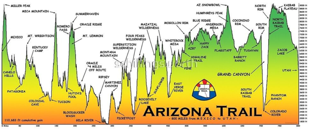
The Arizona National Scenic Trail stretches 800 miles across the entire length of the state to connect deserts, mountains, forests, canyons, wilderness, history, communities and people. This non-motorized trail showcases Arizona’s diverse vegetation, wildlife and scenery, as well as unique historic and cultural sites. The route provides unparalleled opportunities for hikers, mountain bikers, equestrians and other trail users.
Starting at the U.S.-Mexico border, the path climbs and descends from one “sky island” mountain range to another, gaining and losing thousands of feet in elevation and traversing biomes ranging from desert to boreal forest. Continuing across the Sonoran Desert, the route crosses the Gila River, winds through the Superstition Mountains and the Mazatzal Wilderness on its way to the Mogollon Rim and majestic San Francisco Peaks. The trail north takes travelers across the Grand Canyon through billions of years of geology. Topping out on the North Rim, conifer forests dominate the Kaibab Plateau, eventually giving way to red bluffs dotted with sagebrush as the trail nears the Utah border on the edge of the Vermilion Cliffs National Monument. It is the backbone of Arizona.
Whether you hike, run, pedal or ride, the adventure of a lifetime is waiting for you on the Arizona Trail.
View this map and more on www.aztrail.org
Legend: W (water source); N1 (night); TH (trailhead); T1 (resupply bag); * (access to resources)
D1 – 26.9m
0 / 43 Utah Terminus
26.9 / 41 Jacob Lake Inn* – W N1
D2 – 27.5m
43.4 / 41 W
54.4 / 40 N Rim store* N2
D3 – 35.4m
76.1 / 38 GC Lodge North* W
89.8 / 38 Phantom Rnch* W N3
D4 – 29.4m
98.6 / 37 GC Visitor Center* W
105.3 / 37 Tusayan Gen Store* W T1
119.2 / 36 Grandview W N4
D5 – 35.7m
137.1 / 36 Monique Stage Stn
154.9 / 35 Rd Junction N5
D6 – 32.7m
162 / 34 Cedar Ranch Jct PW T2
164.4 / 34 Cedar Ranch W
177.3 / 34 Kelly Tank W
180.6 / 34 FR 418
187.6 / 34 Aspen Corner W N6
D7 – 26.2m
192.3 / 34 Snowbowl Rd PW
196.8 / Flag Urban Trl Jct* (15 miles)
226.8 / 31 Sandy Canyon Trl N7 T3
D8 – 27.1m
244.6 / 30 Pine Grove CG W N8
253.9 / 29 Double Springs CG W N8
D9 – 33.8m
258.3 / 29 Mormon Lake* Jct W
274.8 / 28 Bargaman Tank W
287.7 / 28 Homestead Tank W
D10 – 36.3m
287.7 / 28 Homestead Tank W
295.4 / 27 TH Resupply PW T4
296.6 / 27 Blue Ridge CG W
309.1 / 27 Gen Springs Cyn W
310.1 / 27 Gen Sprgs TH W N10
D11 – 28.4m
312.6 / 26 Washtng Pk TH W
322.6 / 26 Webber Crk TH W
331.8 / 25 Exit to Pine* (1m) W
333 / 25 Bradshaw Tank W
335 / 25 Oak Sprg Trail W
338.5 / 25 Bee Tree Tank W N11
D12 – 30.3m
347.9 / 25 Tank W
351.6 / 25 East Verde River W
368.8 / 23 Hoping Spring W N12
D13 – 35.9m
398 / 22 Wash W
398.5 / 22 Forest Rd 393
402.7 / 22 Hwy 87 Intersection T5
404.7 / 21 Sycamore Crk W N13
D14 – 30.2m
413.4 / 21 Little Pine Flat W
423.3 / 20 Bear Spring W
424.2 / 20 Shake Spring W
434.9 / 20 Mills Ridge TH N14
D15 – 28.1m
443.8 / 19 Roosevelt Marina* W
448.7 / 19 Cottonwood Sprgs W
458.8 / 19 Walnut Sprg W
463 / 19 Reavis Ranch W N15
D16 – 35.7m
477.3 / 18 Reavis Cyn #509 TH W
487.2 / 18 Picketpost TH PW T6
(2.8m from town of Superior)*
498.7 / 16 Rainwater Spigot W N16
D17 – 34.6m
508.1 / 16 Leave River W
510.9 / 16 Gila River W
523.9 / 15 Gila River TH W
525.9 / 15 Florence-Kelvin TH W
533.3 / 15 Ripsey Wash Spring W N17
D18 – 33.2m
539.7 / 15 Wildlife Tank W
551.2 / 15 Freeman Rd TH W
559.4 / 14 Beehive Well W
566.5 / 14 Mnt View Tank W N18
D19 – 34.2m
578.3 / 14 Tiger Mine TH resupply box
579.8 / 13 Hwy 77 resupply PW T7- (N of 77)
(2.6m to town of Oracle)*
586.7 / 12 American Flag TH W?
588.4 / High Jinks Ranch* W Shower
590.1 / 12 Tank W
600.7 / 12 Mount Lemon Visitor Center Town* W N19
D20 – 32.5m
605.6 / 11 Lemmon Creek W
613.6 / 11 Hutch’s Pool W
615.1 / 11 Sabino Canyon W
622.9 Molino Basin TH resupply
633.2 / 9 Redington Pass TH N20 T8
D21 – 30.6m
641.8 / 9 Italian Spring W
644.6 / 9 Chimenea Creek W
648.6 / 9 Grass Shack CG W
654.5 / 9 Creek W
657.4 / 8 Rincon Creek W
663.8 / 8 La Selvilla Picnic Area W N21 – (colossal cave mtn park 1m)*
D22 – 32.6m
666.2 / 8 La Posta Ranch* W
670.3 / 8 Cienega Creek W
676.6 / 7 Sahuarita Rd TH R PW
682.9 / 7 Twin Tanks W
696 / 6 Cattle Trough W N22 T9
D23 – 28.2
706 / 5 Kentucky Camp W
709.7 / 5 Gardner Canyon Rd W?
712.8 / 4 Tunnel Creek TH W
716 / 4 Casa Blana Cyn W
724.6 / 4 Temporal Gulch TH W N23
D24 – 33.4m
729 / 4 Ccc Lakes W
736.3 / 3 Hwy 82 T10
(Patagonia 4m)*
746.6 / 3 Gate Spring W
747.2 / 3 Red Bank Well W
750.5 / 3 Down Under Tank W
758 / 2 Middle Canyon Tank W N24
D25 – 33.3m
765.2 / 2 Parker Canyon W
772.9 / 1 Cement Water Trough W
780 / 1 Bathtub Spring W
786.1 / 1 Montezuma Pass TH
787.9 / 1 Mexico Border
791.3 / 3.4 miles to Coronado National Memorial
FINISH